
Lêer:Thailand Topography.png

Grootte van hierdie voorskou: 338 × 599 piksels. Ander resolusies: 135 × 240 piksels | 271 × 480 piksels | 433 × 768 piksels | 1 198 × 2 123 piksels.
Oorspronklike lêer (1 198 × 2 123 piksels, lêergrootte: 2,24 MG, MIME-tipe: image/png)
Opsomming
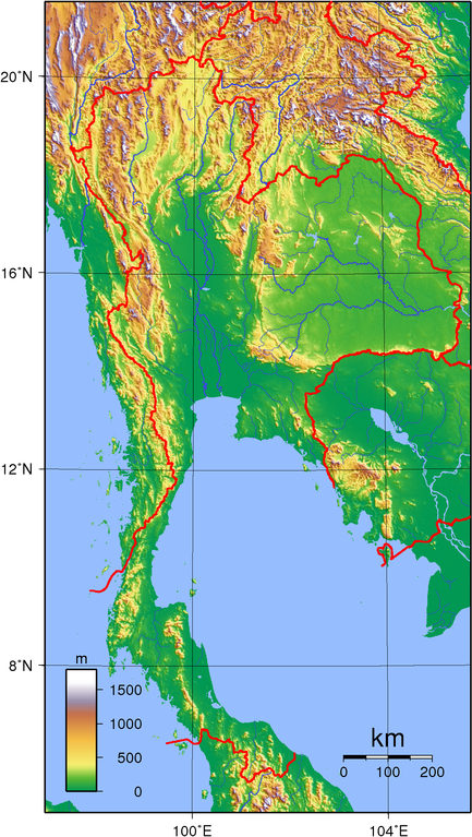
| Beskrywing | Topographic map of Thailand. Created with GMT from publicly released GLOBE data.[1] |
| Datum | |
| Bron | Eie werk |
| Outeur | Sadalmelik |
Lisensiëring
| This work has been released into the public domain by its author, I, Sadalmelik. This applies worldwide. In sommige lande is dit dalk nie wettiglik moontlik nie. Indien so: I, Sadalmelik grants anyone the right to use this work for any purpose, without any conditions, unless such conditions are required by law. |
Lêergeskiedenis
Klik op die datum/tyd om te sien hoe die lêer destyds gelyk het.
| Datum/Tyd | Duimnael | Dimensies | Gebruiker | Opmerking | |
|---|---|---|---|---|---|
| huidig | 09:55, 14 Oktober 2007 | | 1 198 × 2 123 (2,24 MG) | Sadalmelik | better data, better colours |
| 16:23, 9 Junie 2007 |  | 1 171 × 2 123 (2,25 MG) | Sadalmelik | {{Information |Description=Topographic map of Thailand. Created with GMT from publicly released GLOBE data.[http://www.ngdc.noaa.gov/mgg/topo/globe.html] |Source=self-made |Date=June 9, 2007 |Author= Sadalmelik }} [[Category:Maps of T |
Lêergebruik
Die volgende bladsy gebruik dié lêer:
Globale lêergebruik
Die volgende ander wiki's gebruik hierdie lêer:
- Gebruik in ar.wikipedia.org
- Gebruik in az.wikipedia.org
- Gebruik in bg.wikipedia.org
- Gebruik in bxr.wikipedia.org
- Gebruik in da.wikipedia.org
- Gebruik in en.wikipedia.org
- Gebruik in es.wikipedia.org
- Gebruik in fi.wikipedia.org
- Gebruik in fr.wikipedia.org
- Gebruik in hu.wikipedia.org
- Gebruik in id.wikipedia.org
- Gebruik in io.wikipedia.org
- Gebruik in ja.wikipedia.org
- Gebruik in kbd.wikipedia.org
- Gebruik in ko.wikipedia.org
- Gebruik in lt.wikipedia.org
- Gebruik in mn.wikipedia.org
- Gebruik in no.wikipedia.org
- Gebruik in pl.wikipedia.org
- Gebruik in th.wikipedia.org
- Gebruik in uk.wikipedia.org
- Gebruik in vep.wikipedia.org
- Gebruik in vi.wikipedia.org
- Gebruik in www.wikidata.org
- Gebruik in zh.wikipedia.org