
Lêer:Montserrat-CIA WFB Map.png
Geen hoër resolusie is beskikbaar nie.
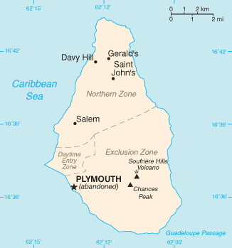
Montserrat-CIA_WFB_Map.png (326 × 349 piksels, lêergrootte: 7 KG, MIME-tipe: image/png)
This image is in the public domain because it contains materials that originally came from the United States Central Intelligence Agency's World Factbook.
|
 |

|
This file has been superseded by Montserrat map - CIA World Factbook 2021.jpg. It is recommended to use the other file. Please note that deleting superseded images requires consent.
|

|
Lêergeskiedenis
Klik op die datum/tyd om te sien hoe die lêer destyds gelyk het.
| Datum/Tyd | Duimnael | Dimensies | Gebruiker | Opmerking | |
|---|---|---|---|---|---|
| huidig | 13:45, 25 Oktober 2021 | | 326 × 349 (7 KG) | Lojwe | Cropped 1 % horizontally, 1 % vertically using CropTool with precise mode. |
| 08:58, 30 Januarie 2006 |  | 328 × 352 (8 KG) | Hoshie | Updated map of Montserrat from the CIA World Factbook, 10 Jan 06 rev: http://www.cia.gov/cia/publications/factbook/maps/mh-map.gif | |
| 09:16, 27 Maart 2005 |  | 330 × 354 (5 KG) | Wolfman~commonswiki | {{CIA-map}} |
Lêergebruik
Die volgende bladsy gebruik dié lêer:
Globale lêergebruik
Die volgende ander wiki's gebruik hierdie lêer:
- Gebruik in diq.wikipedia.org
- Gebruik in en.wikisource.org
- Gebruik in eu.wikipedia.org
- Gebruik in fr.wikipedia.org
- Gebruik in jv.wikipedia.org
- Gebruik in kk.wikipedia.org
- Gebruik in mr.wikipedia.org
- Gebruik in pl.wiktionary.org
- Gebruik in ru.wikipedia.org
- Gebruik in ru.wikivoyage.org
- Gebruik in ta.wikipedia.org
- Gebruik in tr.wiktionary.org
- Gebruik in uk.wikipedia.org