
Lêer:Kyrgyzstan Topography.png

Grootte van hierdie voorskou: 800 × 476 piksels. Ander resolusies: 320 × 190 piksels | 640 × 381 piksels | 1 024 × 610 piksels | 1 705 × 1 015 piksels.
Oorspronklike lêer (1 705 × 1 015 piksels, lêergrootte: 1,54 MG, MIME-tipe: image/png)
Opsomming
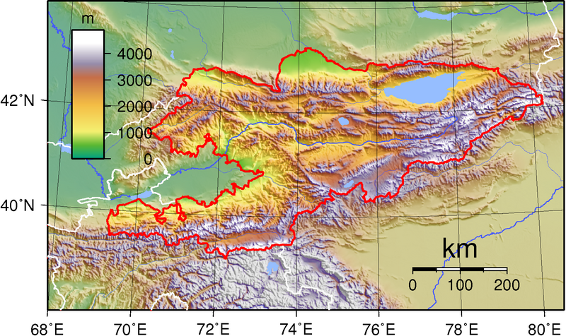
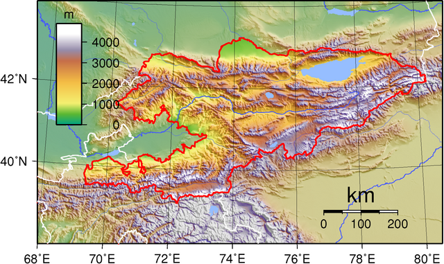
| Beskrywing | Topographic map of Kyrgyzstan. Created with GMT from public domain SRT data. |
| Datum | Datum onbekend |
| Bron | Eie werk |
| Outeur | Sadalmelik |
Lisensiëring
| This work has been released into the public domain by its author, I, Sadalmelik. This applies worldwide. In sommige lande is dit dalk nie wettiglik moontlik nie. Indien so: I, Sadalmelik grants anyone the right to use this work for any purpose, without any conditions, unless such conditions are required by law. |
Lêergeskiedenis
Klik op die datum/tyd om te sien hoe die lêer destyds gelyk het.
| Datum/Tyd | Duimnael | Dimensies | Gebruiker | Opmerking | |
|---|---|---|---|---|---|
| huidig | 13:04, 8 Julie 2007 | | 1 705 × 1 015 (1,54 MG) | Sadalmelik | {{Information |Description=Topographic map of Kyrgyzstan. Created with GMT from public domain SRT data. |Source=self-made |Date= |Author= Sadalmelik }} Category:Maps of Kyrgyzstan Category:Topographic maps of Asia |
Lêergebruik
Die volgende bladsy gebruik dié lêer:
Globale lêergebruik
Die volgende ander wiki's gebruik hierdie lêer:
- Gebruik in ast.wikipedia.org
- Gebruik in azb.wikipedia.org
- Gebruik in ba.wikipedia.org
- Gebruik in bg.wikipedia.org
- Gebruik in bn.wikipedia.org
- Gebruik in ca.wikipedia.org
- Gebruik in cs.wikipedia.org
- Gebruik in el.wikipedia.org
- Gebruik in en.wikipedia.org
- Gebruik in eo.wikipedia.org
- Gebruik in es.wikipedia.org
- Gebruik in fa.wikipedia.org
- Gebruik in gl.wikipedia.org
- Gebruik in hr.wikipedia.org
- Gebruik in hu.wikipedia.org
- Gebruik in hy.wikipedia.org
- Gebruik in id.wikipedia.org
- Gebruik in is.wikipedia.org
- Gebruik in it.wikipedia.org
- Gebruik in ko.wikipedia.org
- Gebruik in ky.wikipedia.org
- Gebruik in lt.wikipedia.org
- Gebruik in mdf.wikipedia.org
- Gebruik in mr.wikipedia.org
- Gebruik in mt.wikipedia.org
- Gebruik in pl.wikipedia.org
- Gebruik in pt.wikipedia.org
- Gebruik in ro.wikipedia.org
- Gebruik in ru.wikipedia.org
- Gebruik in sl.wikipedia.org
- Gebruik in so.wikipedia.org
- Gebruik in tr.wikipedia.org
- Gebruik in uk.wikipedia.org
- Gebruik in vep.wikipedia.org
- Gebruik in yi.wikipedia.org
- Gebruik in zh.wikipedia.org